Sunday, February 24, 2008

Weverton Road to Ed Garvey Shelter

Since the weather is starting to improve and the days are getting longer, we decided to do our first day hike of the Appalachian Trail for 2008. We traveled over the Route 340 bridge from Virginia into Maryland, and made our way to the Weverton Parking Lot, which is right off of the main highway about one mile from the bridge.

The first section of the hike is probably the most difficult, a quick ascent up to the Weverton Cliffs. The elevation change is pretty dramatic for the Maryland Appalachian Trail; you go from around 250 feet up over 1000 feet fairly quickly. Remember this will be a welcome descent for us in June during the Maryland Challenge. Once to the top the Weverton Cliffs provide dramatic views of the Potomac River and then the Loudoun Heights of Virginia.


Looking over the Weverton Cliffs towards Harpers Ferry

We continued another 2 miles to the Ed Garvey Shelter. There was still some snow on the trail, and where the snow had melted it was fairly muddy. I was surprised at the number of other hikers. Maybe the weather brought out the crowds, but we saw over a dozen different groups on our six-mile hike. Once at the shelter we ate a light lunch and relaxed for a bit.

The shelter itself is very nice. There are two levels and ample room to sleep ten. When we arrived there was another couple, who had spent the day clearing trees from various campsites around the shelter. They had also built a fire. It was great to be able to warm ourselves by the fire before venturing back to Weverton.
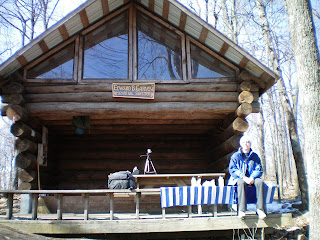

Ed Garvey Shelter

As I mentioned this was a relatively easy hike today, but nice to finally get out of the house and into the outdoors. Look forward to lengthier hikes as the days begin to grow longer.


Appalachian Trial as it Descends towards Weverton Road

Tuesday, February 19, 2008

What is the Maryland Challenge

I wish I could take credit for the idea of hiking the Maryland portion of the Appalachian Trail in one day. However, the inspiration comes from a Washington Post article. The terrain is rather gentle with rolling hills that reach 1800 feet and only moderate elevation changes. Additionally, with enough daylight the trail can be traversed within the day.

Although the idea has probably been discussed for a few years, it was not until this winter that I made a decision to hike the trail. Hopefully, I will have some company. I have chosen a late June hike – June 21st to be exact. There are several reasons for choosing June, usually the weather is comfortable and the days are long. A North – South hike from the Pennsylvania border until Harpers Ferry, WV seems to be the best course. If for no other reason than Harpers Ferry is a lot closer to my home in NOVA.

Currently, my goal is to begin training outdoors in March. I will focus on area hikes between 10 – 20 miles, and keep everyone updated.